
US and EU sanctions on Iran were lifted last weekend in accordance with the nuclear agreement announced in July 2015, paving the way for global energy companies to re-enter the country. While this will probably add to the downward pressure on oil prices in the short term, it also provides new opportunities for cost-effective exploration and enhanced production in an established petroleum province.
Iranian officials are expected to provide full details of the much-anticipated Iran Petroleum Contract (IPC) during a London conference to be held over 22-24 February. Meanwhile, the National Iranian Oil Company has already set up a dedicated web portal with information on the initial contract areas slated for exploration and development. A total of 52 existing oil and gas fields are being marked for development projects, whilst locations for 18 blocks across the length and breadth of the country – including 4 in the Caspian Sea – have now been outlined for exploration bids as part of the IPC (see embedded map beneath).
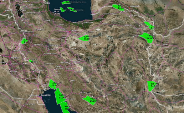
Iran IPC exploration blocks – click to open the Lynx Interactive Licensing Rounds Map
IPC offshore blocks on offer:
- Block 24, Caspian Sea
- Block 26, Caspian Sea
- Block 29, Caspian Sea
- Bamdad, Persian Gulf
- Mahan, Persian Gulf
- Parsa, Persian Gulf
- Sardar-e-Jangal, Caspian Sea
IPC onshore blocks on offer:
- Abadan, Khuzestan province
- Dousti, Razavi Khorasan province
- Kavir, Semnan province
- Moghan, Ardabil province
- Raz, North Khorasan province
- Sarakhs, Razavi Khorasan province
- Sistan, Sistan and Baluchestan province
- Taybad, Razavi Khorasan province
- Timab, Ilam province
- Tudej, Fars province
- Zahab, Kemanshah province
Lynx is able to offer rapid access to critical information through a range of quick-turnaround data reformatting services and non-exclusive studies. Our Iran Exploration Adviser GIS is a complete G&G synthesis which provides essential data for exploration teams who wish to evaluate opportunities in Iran, and the GIS has data coverage over many of the IPC areas in the form of well & field locations & associated databases, surface geology and cross sections, facies & isopach mapping, plus digital seismic and well log data with localised interpretations. The study is completed with a detailed hydrocarbon evaluation report and summary sheets for over 60 fields.If you are interested in learning more about our studies and services, please contact us.