Lynx extensions for ESRI ArcGIS Desktop now support version 10.2

We are pleased to announce the release of new versions of Lynx SeismapLynx Clickrelate and Lynx Rasterlink for ESRI ArcGIS for Desktop, with support added for version 10.2.

The Lynx GIS extensions Seismap, Clickrelate and Rasterlink now support ArcGIS Desktop versions 10.0, 10.1, and 10.2. These extensions work with ArcGIS, providing additional functionality to integrate and visualise your seismic, well data and cross-section data in the context of existing GIS data, managing your document and imagery links from feature class geometries, and providing simple point-and-click access to these linked documents, images, seismic 2D lines and 3D surveys, wireline well logs and well formation tops.

Download trial versions, or upgrade your existing versions of these extensions here.

Posted in Announcements, Clickrelate, GIS, Rasterlink, Seismap, Software | Tagged | Leave a comment

Lynx to exhibit at the AAPG ICE and PESGB-HGS Africa conferences in September

Lynx will be busy exhibiting on both sides on the Atlantic during the month of September: The AAPG International Conference and Exhibition (AAPG link) will be held over the period 8-11 September in Cartagena, Colombia, and marks a first for the event to take place in Colombia. The Latin America/Caribbean region is reputed to possess the second largest oil reserves globally after the Middle East, thanks largely to the heavy oil deposits of the Orinoco Belt and augmented by significant recent discoveries in the deep waters of offshore Brazil. The event is well-timed to coincide with current E&P activity, with 2013 bid rounds taking place in Peru, Trinidad & Tobago, and Brazil – and delegates will be welcomed at the Lynx booth (#101) where one of our staff will ably demonstrate how our technology can help with the challenges of managing the growth of exploration data.

Meanwhile, September 9-11 sees the return of the annual PESGB-HGS Africa Conference to London (PESGB link), where it is this year being staged at Wembley Stadium in a move prompted by the increasing popularity and attendance growth of the event, now in its 12th year. Lynx has contributed to this event ever since its inauguration, with talks, exhibits and through sponsorship. This year, a poster session is being presented by Gareth Williams and David Boote (DBConsulting), entitled ‘Play Fairway Mapping and Risk Assessment of the Sirt Rift Province’, and Lynx will also be exhibiting and showcasing the latest updates to our studies in North, West and East Africa.

Posted in Announcements | Tagged , , | Comments Off on Lynx to exhibit at the AAPG ICE and PESGB-HGS Africa conferences in September

Iraq Petroleum Systems: An interactive GIS atlas and tool-kit

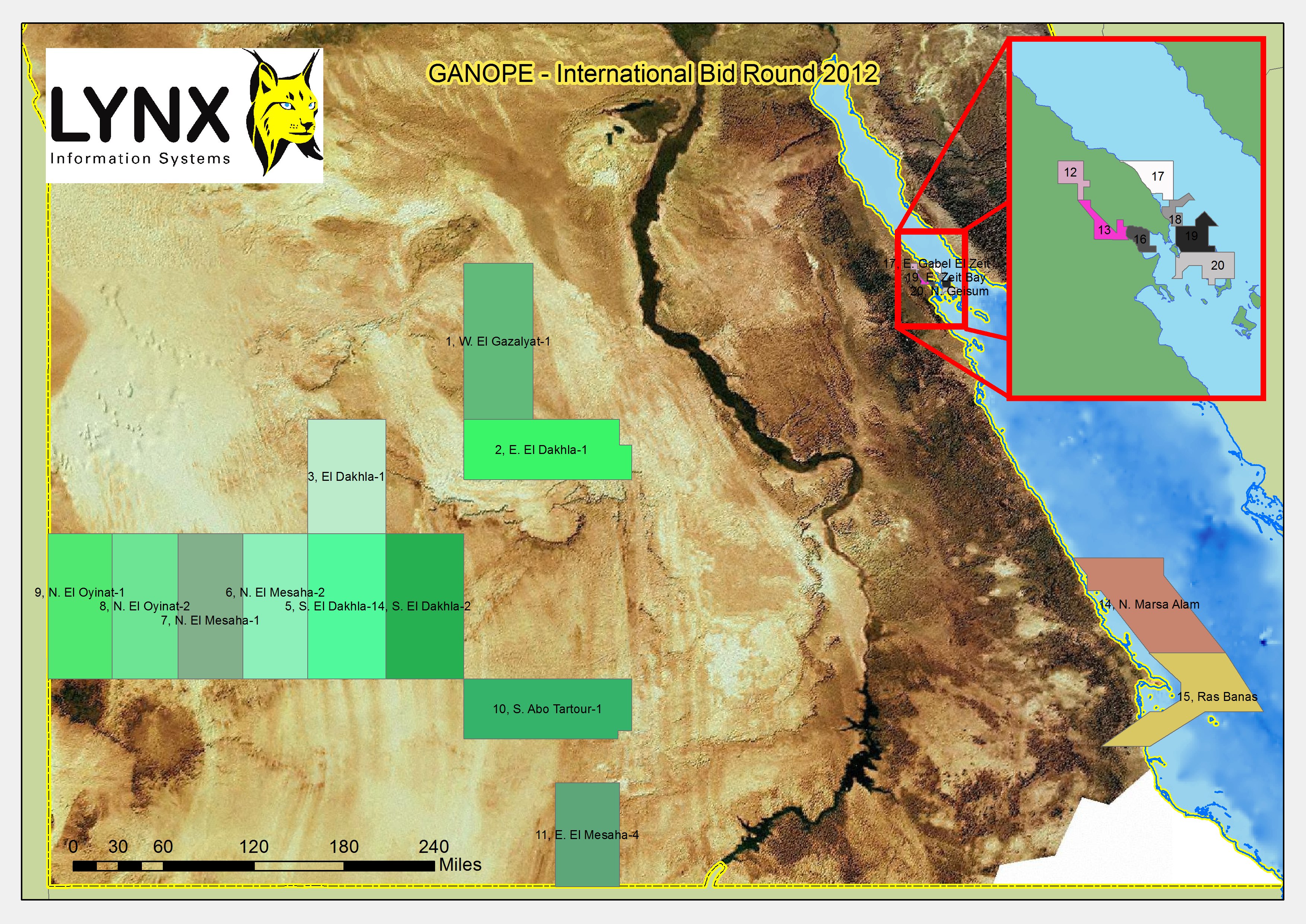
Lynx are pleased to announce the long-awaited release of the Iraq Petroleum Systems multi-client study, carried out in association with David Boote Consulting and Integrated Geochemical Interpretation.

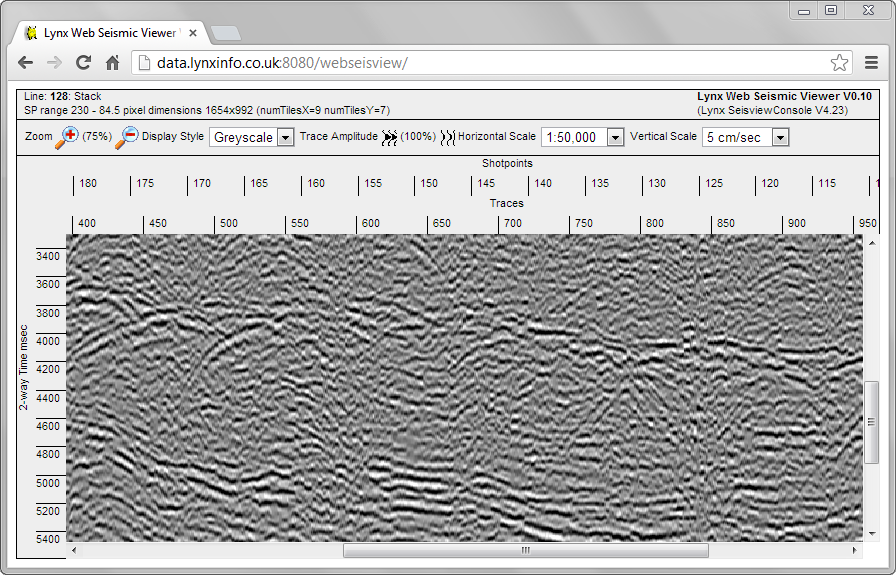
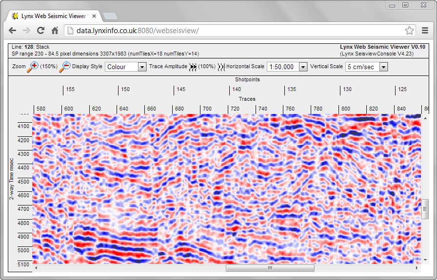
The project is built with ArcGIS at the core, so that all of the 250+ maps are not just static they are made up of dynamic feature classes that are stored in a spatially-related geodatabase, this enables end-users to manipulate and adapt maps to fit with proprietary data and geological models. The ArcGIS project has been designed to work as a library of datasets, from maps to a cross-sections, data tables to geochmical cross-plots; enabling knowledge to be drawn out to fit the explorationists’ needs.

David Boote has refined the regional stratigraphic interpretation and has generated 50+ cross-sections showing lithostratigraphy, chronostratigraphy, as well as more general basin evolution architectural models. He has also produced over 250 maps made up of palaeogeographic facies maps detailing source, reservoir and seal rock deposition at specific time intervals.

At Integrated Geochemical Interpretation (IGI), the geochemical database has been compiled which contains over 2,100 samples from Iraq, Iran, Jordan, Kuwait, Saudi Arabia, Syria and Turkey. The geochemistry has been used to evaluate the source rocks in terms of hydrocarbon potential and maturity, which have been input into the basin modelling, to evaluate the oils in terms of their genetic families, source maturity and alteration. The principal focus of the modelling was the creation of a robust set of depth horizons. 16 horizons were produced, dated from Silurian through to the present surface elevation, covering the whole of the Iraq study area. Depth control from a significant database of drilled formations tops is implicit in these horizons, with appropriate consideration being given to an important series of published depth maps These horizons form the foundation of the 2.5-D burial history model and, coupled with regional maturity and temperature data, and for the first time, resolve the spatial and temporal variations in heat flow for Iraq, allowing a significant improvement in the prediction of the maturation history of all the key source rock intervals.

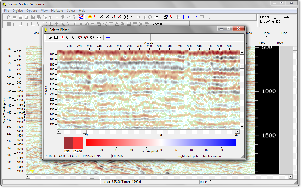
10 Petroleum systems have been mapped and evaluated in great detail, and CRS mapping has also been undertaken using Lynx’s new CRS tool designed specifically for use with this project.

Please download a copy of the Technical Prospectus here or contact ben.sayers@lynxinfo.co.uk for further information or to arrange a demonstration.

Posted in Announcements, GIS, GIS-Development, Movie | Tagged , , , | Comments Off on Iraq Petroleum Systems: An interactive GIS atlas and tool-kit

New developments in seismic software

The Lynx SSV application is a robust and fast method for converting paper seismic sections and scanned seismic images back into digital seismic (SEG-Y) for interpretation or further processing. Over the years, our users have converted many millions of traces back into useful digital data. We are currently beta testing SSV version 25 – a complete restructuring of the SSV application, which adds many improvements to image calibration and display, and project management as well as major new features such as a new color vectorizing algorithm.

This screenshot illustrates SSV vectorizing a color seismic image.

SSV version 25

When vectorizing color seismic, you can choose whether to use one of the standard built-in color palettes (useful for vectorizing directly from seismic screenshots) or you can define your own color palette based on the colors in the image (this can be useful when vectorizing from photographs or compressed images)  – this screenshot shows how the color palette used for seismic display can be edited.

SSV version 25 colour palette editing

We already offer color seismic vectorizing as a service using this new version of SSV. If you would like to find out more about color vectorising, or purchasing/upgrading an LEASSV licence when SSV version 25 is released, please contact us.

We are also working on the initial release of a Web Seismic Viewer. This will be an HTML5 seismic viewer for web browsers, allowing interactive display of seismic data stored on the server through any web browser. The AJAX-enabled seismic viewer in your browser will have a choice of seismic display styles (VA-wiggle, greyscale, color), zoom levels and scales – shown in these screenshots of the prototype.

Web Seismic Viewer - greyscale display

Web Seismic Viewer - variable area/wiggle display

Web Seismic Viewer blue-white-red display

Contact us if you wish to know more about this exciting new development.


Posted in Announcements, Seismic, Software | Tagged , | Leave a comment

Lynx’s GIS Data Management

Lynx Information Systems are serious players in oil industry data management. We are able to integrate all of the key parts of our 20 year history to make spatial databases from current and archive data to enable exploration. Take a look at our short video which explains everything, then email us at lynx@lynxinfo.co.uk to request a free data management consultancy meeting to find out what we can do for you.


Posted in Announcements, GIS, GIS-Development, Movie | Tagged , , , , | Leave a comment

EAGE 2013

Lynx will be exhibiting at the 75th EAGE Conference and Exhibition at the Excel Centre, London on 10-13th June 2013. Come and chat to us at booth 1903 about our geophysical and GIS services and software, and the latest developments of our Lynx Resource Portal.

The LRP is used to successfully manage the UK Onshore Geophysical Library (UKOGL) on behalf of DECC, and can be implemented by Lynx in your organisation to manage and distribute your E&P data. For a live demonstration of the LRP or any of our other software products, contact Lynx or call by our booth (1903) at the EAGE.

Posted in Announcements | Tagged | Comments Off on EAGE 2013

New UK Onshore Geophysical Library web map launched!

Today marks the launch of a new online map interface for the UK Onshore Geophysical Library, which Lynx manage on behalf of the UK Government.

The new interactive map can be found at http://maps.lynxinfo.co.uk/UKOGL_LIVEV2/main.html and has lots more information and functionality available.

UKOGL MAP

UKOGL LIVE V2

The UKOGL LIVE map builds upon its previous success and now provides even more geophysical data for free to users. Seismic images and well formation tops have been extended and complemented with the supply of licencing histories, seismic acquisition parameters and well logging summaries.

For more information take a look at the UKOGL News Feed

Posted in Announcements, GIS-Development, Seismic | Tagged | Comments Off on New UK Onshore Geophysical Library web map launched!

Brazil – 11th Licensing Round

For parties interested in the offerings of the Brazilian 11th bidding round, the ANP have very usefully provided a shapefile download of the available onshore & offshore blocks – see
http://www.brasil-rounds.gov.br/round11/ingles_r11/areas_oferecidas.asp.

Details of a 300-page report into the onshore basins, spatially-enabled by Lynx into an integrated ArcGIS project, can be requested via email to adviser@lynx-info.com.

Posted in Announcements | Tagged | Comments Off on Brazil – 11th Licensing Round

Egypt – GANOPE 2012 Bid Round

The Egyptian Ganoub El Wadi Petroleum Holding Company (GANOPE) have announced a new bid round, with 20 blocks on offer totalling over 125,000 sq km. Of the blocks 11 are located in the Western Desert, 2 in the Eastern Desert, 2 in the Red Sea and 5 in the Gulf of Suez.

Ganope Bid Round Block location Map

Ganope Bid Round Block location Map

The bid round is scheduled to close at noon on Thursday 30th May 2013. More official information from http://www.ganope.com

To download the block boundaries on offer as an ESRI shapefile,  please enter your details before clicking on the link.

Ganope_BidRound2012_Blocks_Lynx.zipshapefile containing open block boundaries for Egyptian GANOPE Bid Round 2012 (approx 5kb)

Note: these block boundaries are not definitive, and are intended only as a guide. The blocks have been digitised by Lynx, and may differ in places from those defined by the governing body.

Lynx Information Systems and its co-venturer Fairway Exploration sell a major, in-depth “GIS Exploration Adviser and Hydrocarbon Potential Report” for Egypt. This in-depth ArcGIS-enabled report and database (with supplementary onshore 2D seismic data) covers all the major producing and frontier basins, and has informed many IOCs in their new ventures exploration. Lynx have recently finished the 2012 Update for the Egypt GIS Exploration Adviser, for more information contact lynx@lynxinfo.co.uk, or view the Egypt page on our website

Posted in Announcements, GIS-Downloads, Industry News, Licensing Rounds | Tagged , | Comments Off on Egypt – GANOPE 2012 Bid Round

PETEX Business Card Draw

On the final afternoon of a successful PETEX show, Lynx asked an independent passer-by to pick the winner of the Pure DAB digital radio from the amazing number of entrants in the business card draw.

Chris Bulley, PETEX prize winner

Chris Bulley, of Hannon and Westwood (colleague Simon Robertshaw pictured with Adam of Lynx), won the prize, exclaiming: “I never win at any of these draws…so I wanted to thank you for breaking my duck and with such a useful prize”.

Lynx would like to thank all those who entered and are keen to hear from anyone who might want more information regarding our Seismic or GIS Data Services.

Posted in Announcements | Tagged , , | Comments Off on PETEX Business Card Draw

PETEX 2012

Lynx will be exhibiting at PETEX 2012 which runs from the 20th – 22nd of November next week at Earls Court 2, London. Please stop by the Lynx booth to catch up with the latest in geospatial services, reports and software from the Lynx team.

Lynx will be showcasing the “new for 2012” Iraq Petroleum Systems GIS Adviser, developed in partnership with DavidBoote Consulting and Integrated Geochemical Interpretion Limited. Please ask one of our exhibitors for a technical demo.

A limited series of two month evaluations for Seismap – ArcGIS extension will be available to exhibition goers. This promotion will be available on disc during the event only from our stand, so please ask for a copy from one of our representatives.

David Boote & Gareth Williams (Lynx Houston) will be presenting Petroleum Systems of the Sirte Basin, Libya as part of the Technical program during Wednesday’s late morning session. David Boote and Gareth Williams co authored Libya – Sirt Basin – A New Petroleum Systems Analysis GIS Adviser if you would like more information about this or our other Adviser products please visit us during the event.

Lynx will also be hosting at The Atlas for Wednesday nights pub crawl event. Stop by our booth to get your free drink stamp, we look forward to seeing everyone there.

Posted in Announcements | Tagged , , , , , , , , , , , , | Comments Off on PETEX 2012

Madagascar Bid Round Rumour

With a bid round rumoured to be held in Madagascar in 2013, Lynx have begun work on upgrading their ever-popular Madagascar GIS Adviser.

The upgrade will add in new interpretations based on seismic and well data; and will also update the well, field and concession databases.

For any geologist, geophysicist or geoscientist interested in exploring either the onshore or offshore of Madagascar then this ArcGIS enabled study is invaluable. Anyone who commits to buy the Madagascar adviser before January 2013 will automatically be entitled to free updates until January 2014, any previous purchasers are also entitled to a discount on an update.

For more information please check out our Adviser page on our website: http://www.lynxinfo.co.uk/gis-madagascar.html or get in touch for a presentation or arrange a live demonstration.

Posted in Announcements, GIS, GIS-Development, Industry News, Licensing Rounds | Tagged , , , , | Comments Off on Madagascar Bid Round Rumour

DAVID BOOTE – LYNX PRESENTING ON SIRT BASIN, LIBYA AT PETEX 2012

At PETEX 2012 (Earls Court, London, 20-22 November), David Boote & Gareth Williams will be presenting a paper on “Petroleum Systems of the Sirt Basin, Libya”, based on an ArcGIS-based multi-client study conducted by DBC and Lynx Information Systems. More information on the study at http://www.lynxinfo.co.uk/gis-libya.html#sirt

Posted in Announcements | Tagged | Comments Off on DAVID BOOTE – LYNX PRESENTING ON SIRT BASIN, LIBYA AT PETEX 2012

Lynx / IGI / David Boote Consulting to present at 4th Iraq Petroleum Conference, London 13-14 September

Lynx Information Systems and technical partners Integrated Geochemical Interpretation and David Boote Consulting will be presenting a series of posters at the 4th Iraq Petroleum Conference to be held at Imperial College in London on 13 and 14 September 2012:

A Modern ArcGIS analysis of Petroleum Systems of Iraq (Ben Sayers, Lynx)
Petroleum Systems of Iraq (David Boote)
Organic Geochemical Evaluation of the Petroleum Systems in Iraq (Raingard Haberer and  Paul Farrimond, IGI)

Conference details from http://www.targetexploration.com/CFP.pdf

Posted in Announcements | Tagged | Comments Off on Lynx / IGI / David Boote Consulting to present at 4th Iraq Petroleum Conference, London 13-14 September

Egypt – EGAS Bid Round Details

The Egyptian Ministry of Petroleum have announced a new EGAS bid round with 15 blocks on offer totalling over 55,000 sq km. Of the blocks 2 are located onshore and 13 are offshore. It is believed that within the next 8 years the Egyptian Petroleum industry will be focussed almost entirely on the exploration for natural gas, evidence for this can be seen in the offshore blocks on offer which are all focussing on natural gas located in the Mediteranean Sea.

EGAS 2012 Blocks Map

Location of EGAS 2012 Blocks

The bid round is scheduled to close at noon on 14th November 2012. More official information from www.egas.com.eg

To download the block boundaries on offer as an ESRI shapefile,  please enter your details before clicking on the link.

Lynx-Egypt-EGAS-blocks-2012-V1.zipshapefile containing open block boundaries for Egyptian EGAS Bid Round 2012 (approx 5kb)

Note: these block boundaries are not definitive, and are intended only as a guide. The blocks have been digitised by Lynx, and may differ in places from those defined by the governing body.

Lynx Information Systems and its co-venturer Fairway Exploration sell a major, in-depth “GIS Exploration Adviser and Hydrocarbon Potential Report” for Egypt. This in-depth ArcGIS-enabled report and database (with supplementary onshore 2D seismic data) covers all the major producing and frontier basins, and has informed many IOCs in their new ventures exploration. Lynx have recently finished the 2012 Update for the Egypt GIS Exploration Adviser, for more information contact lynx@lynxinfo.co.uk, or view the Egypt page on our website

Posted in Announcements, GIS-Downloads, Industry News, Licensing Rounds | Tagged , , | Comments Off on Egypt – EGAS Bid Round Details