Egypt – EGAS Bid Round Details

The Egyptian Ministry of Petroleum have announced a new EGAS bid round with 15 blocks on offer totalling over 55,000 sq km. Of the blocks 2 are located onshore and 13 are offshore. It is believed that within the next 8 years the Egyptian Petroleum industry will be focussed almost entirely on the exploration for natural gas, evidence for this can be seen in the offshore blocks on offer which are all focussing on natural gas located in the Mediteranean Sea.

EGAS 2012 Blocks Map

Location of EGAS 2012 Blocks

The bid round is scheduled to close at noon on 14th November 2012. More official information from www.egas.com.eg

To download the block boundaries on offer as an ESRI shapefile,  please enter your details before clicking on the link.

Lynx-Egypt-EGAS-blocks-2012-V1.zipshapefile containing open block boundaries for Egyptian EGAS Bid Round 2012 (approx 5kb)

Note: these block boundaries are not definitive, and are intended only as a guide. The blocks have been digitised by Lynx, and may differ in places from those defined by the governing body.

Lynx Information Systems and its co-venturer Fairway Exploration sell a major, in-depth “GIS Exploration Adviser and Hydrocarbon Potential Report” for Egypt. This in-depth ArcGIS-enabled report and database (with supplementary onshore 2D seismic data) covers all the major producing and frontier basins, and has informed many IOCs in their new ventures exploration. Lynx have recently finished the 2012 Update for the Egypt GIS Exploration Adviser, for more information contact lynx@lynxinfo.co.uk, or view the Egypt page on our website

Posted in Announcements, GIS-Downloads, Industry News, Licensing Rounds | Tagged , , | Comments Off on Egypt – EGAS Bid Round Details

Ukraine opens deep water bid round

Ukraine has launched a new Petroleum Exploration Bid Round for two extensive deepwater tracts. The 16,700 sq km Skifska block and the 13,600 sq km Foroska block are located off the Crimean peninsula.

According to official news sources, bids should be submitted by 2 August this year. Operators with deepwater experience may be expected to apply, and Work programs of over $300 million will likely be proposed.

Lynx has prepared a shape-file showing the two new blocks, and the other existing two deep water blocks (Prykerchenska – operated by Vanco Prykerchenska Ltd, under renegotiation with government, and Tavriska – status unknown, possibly open) which may be downloaded below .

Prospects in the Prykerchenska block are described thus: “In the northern shallower part, the area contains a prominent Tertiary fold belt with numerous prospective structures that are on trend with the Subbotina  discovery. The deeper (>2000m) southern part of the block contains large structural closures including the Tetyaev High.”

The Subbotina oil and gas discovery well (Chornomornaftogaz, 2006) was drilled on the Kerch Shelf to a TD of 4,300m and tested oil in 4  zones and gas in another (all Oligocene-Lower Miocene).

Lynx commercialises a 3-part Ukraine “GIS Exploration Adviser”, with a wealth of data covering the Black Sea, the Dnieper Donets and the Carpathians: http://www.lynxinfo.co.uk/gis-ukraine.html. The product is designed to assist new ventures geologists looking at opportunities in these different petroliferous regions.

For details of other extensive Ukranian data-sets that Lynx holds, please contact lynx@lynxinfo.co.uk

Download the block boundaries for open blocks as an ESRI shapefile – please enter your details before clicking on the link.

Lynx-Ukraine-offshore-blocks-2012-V1.zipshapefile containing open block boundaries for Ukraine Open Water Bid Round 2012 (approx 4kb)

Note: these block boundaries are not definitive, and are intended only as a guide. The blocks have been digitised by Lynx, and may differ in places from those defined by the governing body.

Posted in Announcements, GIS-Downloads, Licensing Rounds | Tagged , , | Comments Off on Ukraine opens deep water bid round

Lynx Resource Portal for NOCs released

Lynx Information Systems Ltd (www.lynxinfo.co.uk) announces the commercial release of its web-portal and database management system, the Lynx Resource Portal (LRP). This commercial offer is based on the online UK Onshore Geophysical Library interface (www.ukogl.org.uk), which Lynx has designed, built and delivered, in conjunction with operating the Library since 1994. The Library is widely acclaimed as instrumental in reviving UK Onshore Exploration and making petroleum exploration data visible across the internet in real time. It allows geologists to visualise seismic data (and the contextual cultural and geological data), and to make a rapid selection of digital (SEG-Y) sections to purchase from the Library.

The robust technology – which has been developed over a period of 10 years – is based on Oracle and ArcGIS Server software, which are in general use in the industry. The performance of the web portal – using any common web-browser – is exceptional.

Lynx believes that this solution is ideal for National Oil Companies wishing to launch exploration licensing rounds. The system can either be installed in-country on the NOC servers or on secure web-servers operated from Lynx’s offices in London and Houston. All the appropriate data – seismic, well and block data – plus background geology, documentation on licensing conditions, Petroleum Laws and Contracts – can be hosted and served to validated users in real time.

Lynx’s long experience in managing digital and hard-copy data is also available to assist NOCs in attracting new companies to explore.

Lynx Resource Portal - live seismic display

Posted in Announcements, GIS, GIS-Development | Comments Off on Lynx Resource Portal for NOCs released

West Africa Aptian Salt Basin GIS Update

The Lynx/Fairway GIS Exploration Adviser for the West Africa Aptian Salt Basin has recently been updated with additional data and interpretations. Pre-salt plays within the basin have been further evaluated. Discoveries in the Kwanza Basin in Angola, notably the ones made by Cobalt and Maersk this year, have again shown the value of this report.

The project has good data coverage out to a water depth of 2000m and then variable coverage out to 3000m. The regional seismic dataset has been used to map the basement reflector and several other pre-salt horizons, and indications of string reflections in the pre-salt that represent the low velocity source rock intervals within pre-salt grabens.

Several paleogeography maps have been constructed, extending into deep water, and have been used to predict source and reservoir distribution – confirmed by the recent discoveries made by MAersk and Cobalt. Gravity data was also interpreted to give another view of regional structure in deep water.

The project is refined every year; one of the strengths of working in GIS is that this is straightforward. The project has increased considerably in size and detail over the years, and particular attention has been paid to the pre-salt.

More info here.

Posted in Announcements, GIS | Tagged , , , , , , , | Comments Off on West Africa Aptian Salt Basin GIS Update

Exploration Fabric of Africa

The Exploration Fabric of Africa (EFA) project (http://www.efafrica.com) is a project initiated by Lynx director Peter Wigley, as a tribute to his friend Ed Purdy who died in 2009. Dr Purdy was a pioneer in the field of carbonate sedimentology, and he also contributed significantly to the general understanding of African geology, with the publication of his ‘Exploration Fabric of Africa’ maps in 1989.

Exploration Fabric of Africa, 1989

Peter assembled a group of Ed’s friends and former colleagues to update these maps and build an interactive GIS version. All the project contributors gave their time pro bono, and a proportion of proceeds from sales is to be donated to the Africa Now charity (www.africanow.org).

efa2011

The updated GIS provides a general exploration fabric overview for the continent of Africa, plus play fairways, hydrocarbon types, gravity and basement mapping, with links to the AAPG Datapages online journal archive for seismic lines and field locations. The GIS is provided as both an ArcGIS Desktop geodatabase, and as an online interactive map.
Find out more about the EFA project at its website here (www.efafrica.com), or enquire about EFA project sponsorship by contacting EFA Sponsorship Manager Vesna Vokins.

Posted in Announcements, EFA, GIS | Tagged | Comments Off on Exploration Fabric of Africa

Lynx Rasterlink movie demos

Lynx Rasterlink enhances ESRI ArcMap’s support for georectified imagery.

Large collections of georectified imagery are unweildy to view and manage within ArcGIS Desktop. ArcMap MXDs containing a large number of georectified images can be unresponsive and slow to initialise, due to the large size of the raster images, and browsing folders of georectified maps using ArcCatalog can also be slow. Creating a raster catalog can help, but it still does not provide image preview within ArcMap. The Lynx Rasterlink tool adds simple one-click access to georectified images, working from a raster catalog layer or from a ‘raster footprint’ polygon layer.

These 2 movies show how Lynx Rasterlink helps you handle large georectified image datasets – either tiled or overlapping – within ESRI ArcGIS Desktop.

Lynx Rasterlink will work from either a raster catalog, or a standard polygon layer showing raster ‘footprints’ (wire-frame outlines) containing a hyperlink field referencing the georectified image file for each polygon.
Activate the tool by right-clicking on the raster polygon layer in the table of contents and selecting ‘Lynx Rasterlink: Activate for this Layer’ from the context menu (or alternatively you can activate it from the Lynx Toolbar), and then click on the map to select the surrounding georectified image or images. If more than one polygon surrounds the point you clicked, then a dialog box will list them all – selecting an item in this dialog causes its extent to flash, so that large- and small-scale maps can be distinguished.

Lynx Rasterlink is compatible with ESRI ArcGIS Desktop V10 and V9.3.
For more information, see here, or download an evaluation here.

Posted in GIS, Movie, Rasterlink, Software | Comments Off on Lynx Rasterlink movie demos

Lynx Seismap – New Release supports import to file geodatabases

Lynx is pleased to announce release 4.2 of Lynx Seismap for ESRI ArcGIS Desktop versions 10 and 9.3. This new release adds support for importing common E&P data types into file geodatabase feature classes and raster grids:

  • import UKOOA/SEG-P1/CSV seismic shotpoint/CDP location files to file geodatabase polyline-M feature classes
  • import Z-Map ASCII grid file to file geodatabase raster grid
  • import interpreted seismic horizon/fault polyline ASCII files to file geodatabase polyline-ZM feature class

For more information check out Seismap’s web page, watch some short movie demos here, and download a trial version of Seismap, plus a demo dataset from here.

Posted in GIS, Seismap, Software | Comments Off on Lynx Seismap – New Release supports import to file geodatabases

Egypt – EGPC 2011 Bid Round

The Egyptian General Petroleum Corporation (EGPC) has recently launched a new 2011 Bid Round, with a closing date scheduled for January 30th, 2012.  The offered blocks are located in the Western Desert, Eastern Desert, Gulf of Suez and Sinai Peninsula.  See http://www.egpc.com.eg for the official announcement and further details.

Egypt EGPC 2011 Bid Round map

EGPC 2011 Bid Round

View this map as a PDF

Lynx has compiled a shapefile of the offered blocks, available here for download.
Please enter your name and email address to download the zipped shape file.

SORRY! This Link has expired. Please see the Lynx Regional Adviser or the Lynx Blocks & Concessions map for details about the location of this bid round

Lynx and Fairway Exploration Ltd have an established Exploration Adviser GIS and Evaluation Report with data for each of these areas, which has recently been updated for 2011.  See more information here.

Posted in GIS-Downloads, Industry News, Licensing Rounds | Tagged | Comments Off on Egypt – EGPC 2011 Bid Round

New – Lynx Risk Mapping Tool for ArcGIS Desktop

Lynx is currently developing a new Hydrocarbon Play Component Risk Segment (CRS) mapping tool for ESRI ArcGIS Desktop. Risk mapping is a powerful application of GIS technology, presenting a visual synthesis of all available data by combining ‘risk factors’ for individual layers.

This movie shows a preview of the Lynx CRS Tool, demonstrating the creation of a composite play risk map from hydrocarbon source, reservoir and seal layers.

Check back here for development progress reports, or contact us for more details

Posted in CRSTool, GIS, Movie, Software | Leave a comment

Iraq – Petroleum Systems: An ArcGIS-enabled Study and Interactive Toolkit – beta copy available

Lynx’s multi-client study, carried out in association with David Boote Consulting and Integrated Geochemical Interpretation, is taking shape and a beta copy will be available for viewing in September. We are on target for December release, for use by explorationists studying the petroleum exploration opportunities in the Iraq 4th  Licensing Round.

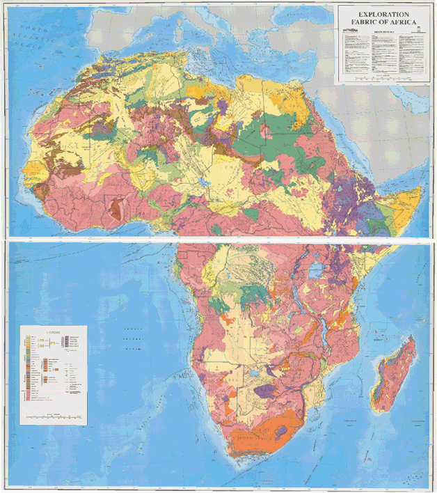
David Boote has been refining the regional stratigraphic interpretation and generating the high-definition cross-sections, and also revising the palaeogeographic facies maps.

At Integrated Geochemical Interpretation (IGI), the geochemical database has been compiled and contains over 2,100 samples, 643 of these being from Iraq, the remainder from Iran, Jordan, Kuwait, Saudi Arabia, Syria and Turkey. IGI is currently adding location data (lat/long) and lithostratigraphy where necessary.

The next stages on the geochemical side are to evaluate the source rocks in terms of hydrocarbon potential and maturity, to feed into the basin modelling, and to evaluate the oils in terms of their genetic families, source maturity and alteration.

The principal focus of the modelling study to date has been the creation of a robust set of depth horizons. Some 16 horizons are in the process of being compiled, dated from Silurian through to the present day and covering the whole of the Iraq study area. Depth control from a significant data base of drilled formations tops is implicit in these horizons, with appropriate consideration being given to an important series of published depth maps. Once compiled, these horizons will form the foundation of the 2.5-D burial history model and, coupled with regional maturity and temperature data will, for the first time, resolve the spatial and temporal variations in heat flow for Iraq, allowing a significant improvement in the prediction of the maturation history of all the key source rock intervals.

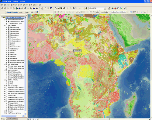
Lynx is working on the (x,y,z) structural grids in ArcGIS. These are essential to pass back to the basin modelers at IGI, to solve the heat-flow in space (x,y,z) and time.

Please  download a copy of the Technical Prospectus here or contact us at lynx@lynxinfo.co.uk

Posted in Announcements, GIS, GIS-Development, Licensing Rounds | Tagged | Comments Off on Iraq – Petroleum Systems: An ArcGIS-enabled Study and Interactive Toolkit – beta copy available

Libya – Time to Rediscover the Sirt Petroleum Province

With events in Libya moving dramatically in the last few days, NOW is the time to rediscover the Sirt Petroleum Province and its massive exploration potential.

Lynx and David Boote have produced a multi-client report entitled: An ArcGIS-based study of the Sirt Petroleum Systems: An Encyclopedia and Interactive Tool-kit.

The study maps all the important petroleum systems in space and time, and analyses petroleum generation, migration, entrapment and late-stage alteration. It draws on an extensive database of exploration and field data (included in the package).

The workflow in the study identifies plays and prospects, and also goes into common risk segment (CRS) mapping.

Geoscientists can build on the reference data to evolve their own ideas – and use the ArcGIS product to database all other relevant corporate data as well.

A PDF slide-set describing the product is downloadable here, and more information is available in this PDF poster presentation, and on our website here.

With Libya set to re-establish itself as a premier oil producer (and exploration location) in North Africa, the time to react is NOW.

Please contact us to arrange a viewing: lynx@lynxinfo.co.uk

Posted in GIS, GIS-Development | Tagged | Comments Off on Libya – Time to Rediscover the Sirt Petroleum Province

Lynx at PESGB-HGS Africa Meeting, QEII Conference Centre, London 7 – 8 September

Lynx will have a stand at the 10th annual PESGB-HGS Africa meeting – A Legacy of Exploration and Discovery.

Clients can review new ArcGIS projects designed for the oil-company new ventures geoscientist, such as the “GIS Exploration Adviser for Tanzania”.
Lynx (Gareth Williams), with consultant geologist David Boote, also has a technical poster on “ArcGIS Spatial Analysis of Petroleum Systems in the Sirt Petroleum Province, Libya”

Posted in Announcements | Comments Off on Lynx at PESGB-HGS Africa Meeting, QEII Conference Centre, London 7 – 8 September

Iraq – 4th Licensing Round

According to the press agencies, the 4th Licensing Round is now set for 25-26 January 2012 (as opposed to November 2011). Lynx has compiled shape-files of the blocks which can be downloaded below. Some 12 blocks are to be offered, essentially in the west of the country which is relatively unexplored. However, there have also been calls to the Oil Ministry from the parliamentary committee to delay the round until new legislation is passed.

SORRY! This Link has expired. Please see the Lynx Regional Adviser or the Lynx Blocks & Concessions map for details about the location of this bid round

Lynx, in association with David Boote Consulting, and Integrated Geochemical Interpretation (IGI) is preparing a new ArcGIS-enabled study and interactive tool-kit on the Petroleum Systems of Iraq. The tool-kit is designed to allow interpreters to build play fairway maps for regional synthesis, and make play and prospect risk assessments.

The deliverables will include: a full suite of regional gross facies maps and sections, source rock distribution and maturity maps (created using ZetaWare Trinity modelling software) linked together in a number of  petroleum systems/play fairway analysis modules supported by a Trinity model discribing the maturation history of the more significant source rocks. The tool-kit will also include a suite of ArcGIS plug-ins developed by Lynx for visualising seismic data and well-log data.

Full details and a downloadable prospectus are available here.

Posted in Announcements, GIS, GIS-Development, GIS-Downloads, Industry News, Licensing Rounds | Tagged , | Comments Off on Iraq – 4th Licensing Round

Mexico Licensing Round

Mexico’s state-run oil company Petroleos Mexicanos (Pemex) launched a 1st international bid round on November 24th 2010, releasing three contract areas enclosing 6 mature fields. Data rooms for the Magallanes, Santuario and Carrizo blocks are already running. A shapefile of the three blocks can be downloaded here.

Download the block boundaries for open blocks as an ESRI shapefile – please enter your details before clicking on the link.

SORRY! This Link has expired. Please see the Lynx Regional Adviser or the Lynx Blocks & Concessions map for details about the location of this bid round

Lynx are specialists in data-room services, with the capacity to quickly work-up and turnaround bid round data and efficiently build exploration potential assessment GIS projects. Please contact us for more details.

Note: these block boundaries are not definitive, and are intended only as a guide. The blocks have been digitised by Lynx, and may differ in places from those defined by the governing body.

Posted in GIS-Downloads, Industry News, Licensing Rounds | Tagged | Comments Off on Mexico Licensing Round

New Tanzania GIS Released

Lynx Information Systems announces the release of our new Tanzania GIS Adviser. This provides a comprehensive integrated geological and geophysical assessment of the hydrocarbon potential of Tanzania and is an essential synthesis of petroleum exploration data to aid the new ventures geologist.

Tanzania GIS Adviser - Hydrocarbon Plays

For more information, and to view the complete Adviser contents listing, see http://www.lynxinfo.co.uk/gis-tanzania.html

Posted in Announcements, GIS, GIS-Development | Tagged | Comments Off on New Tanzania GIS Released