Lynx Presenting at the ESRI PUG Houston

If you’re attending the ESRI PUG in Houston make sure you make a note to stop by Ballroom C at 15:30 on 19th April to listen to Lynx’s experiences in ‘Managing a Country’s Archive‘.
The presentation, given by Ben Sayers, will provide technical and historical information on the compilation of the UK Onshore Geophysical Library (UKOGL), which is managed by Lynx.
Get ahead of the crowd and take a look at the UKOGL LIVE now at: http://maps.lynxinfo.co.uk/UKOGL_LIVE/map.html

Posted in Announcements, GIS, GIS-Development, Industry News | Tagged , , , | Comments Off on Lynx Presenting at the ESRI PUG Houston

Iraq – A New GIS-enabled Petroleum Systems Analysis

An Iraqi exploration bid round is to be opened late in 2011. Lynx Information Systems, in association with David Boote Consulting and IGI, is compiling an “interactive tool-kit” to provide a better understanding of the known petroleum systems in Iraq.

The tool-kit is designed to allow interpreters to build play fairway maps for regional synthesis, and make play and prospect risk assessments.

Geochemical analyses – 3D basin models – are to be run by IGI, using the Trinity modelling software.

The deliverables will include: a full suite of regional gross facies maps, source rock distribution and source rock maturity maps, regional cross-sections, field cross-sections. The tool-kit will also include a suite of ArcGIS plug-ins developed by Lynx for visualising seismic data and well-log data.

Contact us for more details on project content and progress.

Posted in Announcements, GIS-Development | Tagged , | Comments Off on Iraq – A New GIS-enabled Petroleum Systems Analysis

Lynx Seismap demo movies 3 and 4 – grids and horizons

Movie 3 shows how ZMap ASCII grid files mapping interpreted surfaces can be quickly imported into ESRI raster grid format in ESRI ArcMap, using the Lynx Seismap extension for ESRI ArcGIS Desktop.

Lynx Seismap provides automatic reinterpolation of the ZMap grids during the import process if required to convert rectangular ZMap grid cells into square ESRI raster grid cells.

Movie 4 shows how interpreted seismic horizons and faults can be imported to polyline-ZM features, displayed on seismic profiles, and exported.

Download a trial version of Lynx Seismap here.

Posted in GIS, Movie, Seismap, Software | Comments Off on Lynx Seismap demo movies 3 and 4 – grids and horizons

Lynx Seismap movie demo 2 – TWT Surface Display and Export

This movie demo for Lynx Seismap uses data from the Lynx West Africa GIS Adviser in Gabon to illustrate the display and export of two-way-time gridded surfaces with seismic data within ESRI ArcMap, and export to Z-Map format.

Lynx Seismap interpolates horizons for seismic overlay from TWT surfaces stored either as grids or TINs, so that the interpretation is displayed on live seismic profiles

Note: this movie has no soundtrack.

For more details about Lynx Seismap, see here, or download a trial version here.

Posted in GIS, Movie, Seismap, Software | Comments Off on Lynx Seismap movie demo 2 – TWT Surface Display and Export

GIS Petroleum Training Courses – 2011 Syllabuses Updated

Lynx are the GIS specialists for the Petroleum Industry and are keen to help other members of the community maximise their GIS skill-set. As an ESRI business partner and users of ESRI technology for over 15 years we have the experience and the expertise to instruct and enable others to benefit from our knowledge.

Different course levels are available, so whether you’re a beginner, a moderate user or a power user we have a programme which will benefit you perfectly. We also have a specific course aimed at non-GIS using Management, enabling you to lead your teams with full knowledge.

The 2011 course syllabuses now include:

Beginner
The beginner course is targeted at individuals who have either never used a GIS before as well as
those who have been out of the loop for a while. The course involves:
• Basic concept and functions of a GIS System
• Visualisation
• Creating maps
• Querying data
• Analysing simple datasets
• The importance of Metadata

After completing the course the attendee should be able to:
• Understand what a GIS is.
• Use basic functionality
• Create maps for printout and inclusion in presentations
• Query both spatial and tabular data
• Understand different types of geometric data
• Appreciate different projections and coordinate systems.
• Georeference raster data
• Digitise information for inclusion in a GIS

Intermediate
The Casual User course is aimed at petroleum professionals who use GIS in their general day-to-day
workflows. The course ensures the attendees understand:
• How to organise and use spatial data in a Geodatabase.
• Geodetics
• How to edit spatial data
• Using symbology and labelling to graphically represent data
• Incorporate ASCII data into ArcMap, eg. navigation data
• Query GIS data to provide useful statistics to make business decisions.
• Defining relationship classes to explore linked data
• Creating grids from contour input using spatial analysis
• Editing complex geometry, eg. concession blocks
Once complete the attendee will have confidence and ability to work with spatial data efficiently and
accurately.

Power User
The Power User course is aimed at professionals who use GIS daily and are comfortable with
manipulation of geometry. The course will provide the attendee with the following specific skills:
• Ability to integrate diverse data sources and create rich knowledge based maps
• Solve spatial data management alignment issues
• Build geoprocessing models to quickly save time on complex tasks
• Use complex definition queries
• Creating common risk segment and play maps based
• ArcMap and SMT Kingdom interfacing
• Mapping migration pathways
• Volumetric and prospect evaluation
• Using Lynx tools to integrate SEG-Y

Tailor-made solutions
Lynx also provide bespoke on-site training courses to better suit the ability and necessary skills of the attendees. The courses are primarily designed to complete a specific company objective, though they can be based on a selection of goals from the Beginner, Intermediate or Power User courses.

Lynx Lunch and Learns (L&L)
An ever increasingly popular option for the tailor-made solutions; Lynx specialist training personnel arrive on-site over the lunch period and provide a two hour training session to a rolling employee attendance. During the L&L the Lynx staff demonstrate how the full potential of GIS can be released and integrated into a G&G workflow. The L&L starts off basic, aimed at managerial level, who need to be aware of the ability of GIS but not actually have to use it, right up to a power GIS Analyst level with an amalgamation of processes to quickly harness the power of GIS and show off some of the advanced features.

Server based training
The server based training encompasses SDE database related tasks, as well as ArcGIS Server services and web mapping applications. Lynx staff can arrive on-site and asses the current situation and provide consultancy to bridge the gap between IT and GIS departments and assist in providing advice to reach the best solution to manage the spatial data associated with the petroleum industry.

Lynx can assist companies in building Spatial RDBMS (Relational Database Management System) which can be accessed through internal Intranet systems and also provide web-based mapping application design and development assistance to serve data over the Internet.

Contact Ben Sayers (ben.sayers@lynxinfo.co.uk) for more information.

Posted in Announcements, GIS, Software | Tagged , , , , , , | Comments Off on GIS Petroleum Training Courses – 2011 Syllabuses Updated

GIS field atlases for Eastern Europe

Available from Lynx are a series of ArcGIS-based field atlases covering Ukraine, Romania and (in-development) Poland. Adapted in-part from publicly available data and augmented with well & seismic data, these atlases provide a foundation for exploration new ventures and field redevelopment reconnaisssance work.

Posted in Announcements, GIS, GIS-Development | Tagged , , | Comments Off on GIS field atlases for Eastern Europe

New Tanzania GIS

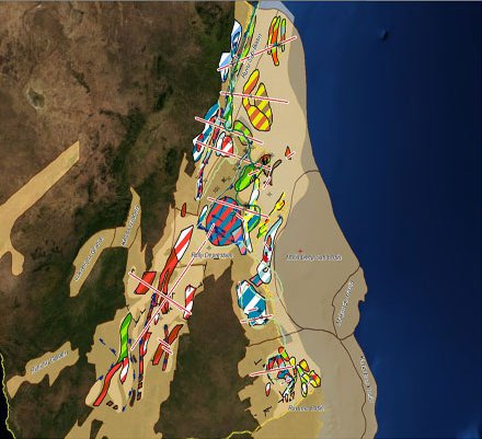
Lynx Information Systems and Fairway Exploration are to launch a new GIS Exploration Adviser for Tanzania, an ArcGIS-based study comprising a detailed assessment of the petroleum geology and hydrocarbon potential of both onshore and offshore sedimentary basins of Tanzania, highlighting play concepts and major prospective trends. The project aims to bring companies up to date with the fast-growing body of knowledge concerning the petroleum geology of eastern Africa in light of recent significant discoveries, and will complement existing Lynx studies on Madagascar and regional East Africa.

Posted in Announcements, GIS, GIS-Development | Tagged | Comments Off on New Tanzania GIS

Lynx Clickrelate movie demo

This movie demonstrates how the Lynx Clickrelate extension for ESRI ArcGIS Desktop can be used to display well and field reports in a ArcGIS project.

For more details about Clickrelate, see here, or download a trial version here.

Posted in Clickrelate, GIS, Movie, Software | Comments Off on Lynx Clickrelate movie demo

Lynx Seismap movie demo

The Lynx Seismap extension for ESRI ArcGIS Desktop is demonstrated in this 4-minute YouTube video, integrating seismic, wireline and cross-section data into your GIS projects.

This movie shows:

  • live seismic (SEG-Y) data view from ArcMap, with interactive zoom, scroll and map positioning
  • simplified shotpoint annotation for seismic basemaps, using a customised dialog with straightforward shotpoint terminology
  • live wireline (LAS) data view from ArcMap, with interactive zoom and scroll
  • cross-section view from ArcMap, with interactive zoom, scroll and map positioning

For more details about Lynx Seismap, see here or download a trial version here.

Note: this video is silent, with no soundtrack. In-movie captions explain the main features demonstrated.

More videos coming soon.

Posted in GIS, Movie, Seismap, Software | Comments Off on Lynx Seismap movie demo

Australia Northwest Shelf GIS

Lynx announces a new GIS for Australia in response to client demand, with interest focused on the Northwest Shelf gas province. This GIS features data sourced from both public domain and Lynx-owned resources, and is intended to serve as a foundation for further analysis of this region, which Lynx will undertake in the first half of 2011.

Please contact us for more details of this development.

Posted in Announcements, GIS, GIS-Development | Tagged | Comments Off on Australia Northwest Shelf GIS

Indonesia to launch Second 2010 Licensing Round

Indonesia is due to launch its second bid round for 2010 on 10th December. Submissions are due on 9th Februrary 2011 for direct proposal blocks, and 25th April 2011 for the regular tender blocks. See the MIGAS website for more details and the official announcement.

Lynx are specialists in data-room services, with the capacity to quickly work-up and turnaround bid round data and efficiently build exploration potential assessment GIS projects. We also offer a South-East Asia GIS Adviser, which provides a regional framework for evaluation and interpretation. Please contact us for more details.

Download the block boundaries for open blocks as an ESRI shapefile – please enter your details before clicking on the link.

SORRY! This Link has expired. Please see the Lynx Regional Adviser or the Lynx Blocks & Concessions map for details about the location of this bid round

See Downloads – Browser Compatibility.

Note: these block boundaries are not definitive, and are intended only as a guide. The blocks have been digitised by Lynx, and may differ in places (eg coastal regions) from those defined by the governing body.

Posted in GIS-Downloads, Industry News, Licensing Rounds | Tagged | Comments Off on Indonesia to launch Second 2010 Licensing Round

Lynx – Come and see us at PETEX 2010

The Petex 2010 exhibition and conference takes place at Earl’s Court in London from 23 to 25 November 2010 (www.petex.info). Come and see Lynx on stand A9, near the front entrance. Lynx staff are on-hand to discuss service capabilities (data reconstruction, data integration through ArcGIS and ArcSDE), bespoke software (including the latest release of the seismic vectorising suite, SSV 25), plus our range of GIS Exploration Advisers for international new ventures.

Lynx is also hosting a pub-evening on Wednesday after the show, at the nearby “Atlas” pub. Get your Petex card stamped, and come along for a beer!

Posted in Announcements, Industry News | Comments Off on Lynx – Come and see us at PETEX 2010

Egypt GPC International Bid Round 2010

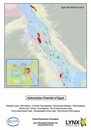
EGYPT – The General Petroleum Company (GPC) has announced its International Bid Round for 2010, including 13 onshore and offshore blocks in the Gulf of Suez region. See the map and shapefile below for block locations.

Egypt GPC Bid Round 2010 Offered Blocks (PDF map)

For more details see the official GPC announcement.

Please contact us for details of our Egypt GIS Adviser, seismic and well data and data room services.

Download the block boundaries for open blocks as an ESRI shapefile – please enter your details before clicking on the link.

SORRY! This Link has expired. Please see the Lynx Regional Adviser or the Lynx Blocks & Concessions map for details about the location of this bid round

See Downloads – Browser Compatibility.

Note: these block boundaries are not definitive, and are intended only as a guide. The blocks have been digitised by Lynx, and may differ in places (eg coastal regions) from those defined by the governing body.

Posted in GIS-Downloads, Industry News, Licensing Rounds | Tagged | Comments Off on Egypt GPC International Bid Round 2010

UKOGL LIVE – Launched

Lynx are pleased to announce the launch of the UK Onshore Geophysical Library‘s new web mapping application – UKOGL LIVE.

UKOGL LIVE - http://maps.lynxinfo.co.uk/UKOGL_LIVE/map.html

UKOGL LIVE

Using UKOGL LIVE, users have free access to a plethora of onshore UK oil industry data, including:

  • Licence block information, 3D survey locations and onshore field locations.
  • Navigation data for all of the archived UK onshore seismic data- using UKOGL LIVE, users can browse the information via a graphical map front-end, or search and view specific 2D lines using the built in search tools.
  • Seismic images – For the majority of 2D seismic lines, there are high resolution free-to-view Colour and Greyscale images of the SEG-Y data.
  • Well locations – users can view well locations and access intersected formation top depths in downloadable PDF format.
  • Regional seismic profiles – there are currently three regional profiles across important basins of the onshore UK, with more currently being compiled,and as with the 2D lines there are also downloadable JPEG images.

In addition to the Oil Exploration specific data other important features to note are: fully integrated selectable background imagery, extended search facilities with auto zoom and an A4 output map generator.

The UK Onshore Geophysical Library (UKOGL) was established in 1994 in conjunction with the Department of Trade and Industry now the Department of Energy and Climate Change (DECC) and the UK Onshore Operators Group (UKOOG).

Lynx GIS Developers have harnessed the power of ERSI’s ArcGIS Server and developed UKOGL LIVE using the ArcGIS JavaScript API.

This is the first public release of an exciting set of planned development phases, with phase two currently in production at Lynx, which will provide even greater online functionality to the explorationist.

Take a look at the map today via: http://maps.lynxinfo.co.uk/UKOGL_LIVE/map.html

Posted in Announcements, GIS | Comments Off on UKOGL LIVE – Launched

Egypt Ganope Bid Round 2010

EGYPT – the Ministry of Petroleum Ganoub El Wadi Petroleum Holding Company (Ganope) has just announced the International 2010 Bid Round 1, including 7 blocks in the Eastern Desert And South Of Western Desert – see the map below. Closing date for bids is 20th December 2010.

Egypt - Ganope 2010 International Bid Round (PDF map)

For more details, see the official Ganope website at www.ganope.com, and the official announcement.

Please contact us for details of our Egypt GIS Adviser, seismic and well data and data room services.

Download the block boundaries for open blocks as an ESRI shapefile – please enter your details before clicking on the link.

SORRY! This Link has expired. Please see the Lynx Regional Adviser or the Lynx Blocks & Concessions map for details about the location of this bid round

See Downloads – Browser Compatibility.

Posted in GIS-Downloads, Industry News, Licensing Rounds | Tagged | Comments Off on Egypt Ganope Bid Round 2010